 These street types are not intended to replace official functional transportation classifications (shown in the Transportation Element of the San Francisco General Plan) but instead are meant to serve as a guide for designing appropriate streetscape environments. Note that this is coming from the San Francisco Planning Department and the links are all to their website.
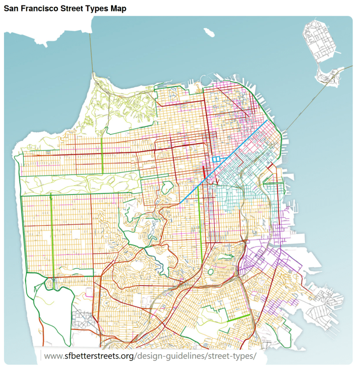
The Better Streets Plan establishes the following street types:
Commercial
Residential
Industrial/Mixed-use
Special
- Parkways
- Park Edge Streets
- Park Interior (coming soon)
- Multi-way Boulevards
- Ceremonial (Civic) Streets
- Alleys
- Shared Public Ways
- Paseos (Pedestrian-Only Streets)
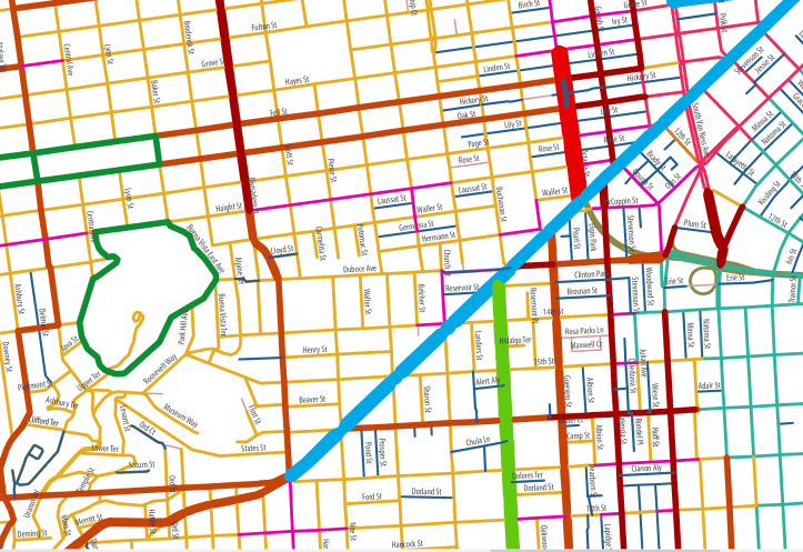
Throughway streets carry greater volumes and higher speeds of vehicle traffic, while neighborhood streets have lower speeds and volumes. Throughway streets (both residential and commercial) include streets identified in the San Francisco General Plan Transportation Element Map 6: Vehicular Streets as “Major Arterial,” “Transit Conflict Street,” or “Secondary Arterial.” Neighborhood streets (both residential and commercial) are those streets not identified as such.
Excerpts from The San Francisco General Plan Transportation Element published by the SF Planning Department:
There should be a hierarchical system of streets functioning in accordance with the planned movement of vehicles and the management of congestion. Street design, capacity and treatment should be a direct manifestation of the streets intended use in satisfying both present and prospective travel demand, and also its non-traffic purposes such as open space and pedestrian movement. It is recognized that in some cases it will be necessary to determine a maximum level of traffic for which street capacity will be provided, implying a tolerable level of congestion as a constraint, if other objectives of the city are to be attained.
Safety and livability along the city streets are primary concerns. This element seeks to balance the needs for vehicle circulation in the provision for through traffic on major arterials and discouragement of it on local streets, particularly residential streets.
Certain streets, such as Geary Boulevard, Van Ness Avenue, Columbus Avenue and The Embarcadero, are important to more than one mode of transportation, and a balance of transportation systems must be maintained. Even with ample right-of-way width, the ability of these streets to be all things to all users is inherently compromised.
|
TABLE 1: CLASSIFICATION OF ELEMENTS IN VEHICLE CIRCULATION PLAN
*Pedestrian and bicyclist use will occur and need to be provided for on all street classifications except freeways. |
| Freeways
Limited access, very high capacity facilities; primary function is to carry intercity traffic; they may, as a result of route location, also serve the secondary function of providing for travel between distant sections in the city. Major Arterials Cross-town thoroughfares whose primary function is to link districts within the city and to distribute traffic from and to the freeways; these are routes generally of citywide significance; of varying capacity depending on the travel demand for the specific direction and adjacent land uses. Transit Conflict Streets Streets with a primary transit function which are not classified as major arterials but experience significant conflicts with automobile traffic. Secondary Arterials Primarily intra-district routes of varying capacity serving as collectors for the major thoroughfares; in some cases supplemental to the major arterial system. Recreational Street A special category of street whose major function is to provide for slow pleasure drives and cyclist and pedestrian use; more highly valued for recreational use than for traffic movement. The order of priority for these streets should be to accommodate: 1) pedestrians, hiking trails or wilderness routes, as appropriate; 2) cyclists; 3) equestrians; 4) automobile scenic driving. This should be slow and consistent with the topography and nature of the area. There should be adequate parking outside of natural areas. Collector Streets Relatively low-capacity streets serving local distribution functions primarily in large, low-density areas, connecting to major and secondary arterials. To be identified in area plans. Local Streets All other streets intended for access to abutting residential and other land uses, rather than for through traffic; generally of lowest capacity. Living Streets “Living streets” can include streets, alleys and other public rights-of-way. They serve as both an open space resource for residents and visitors as well as a thoroughfare for local traffic. Physical improvements to living streets should include traffic calming measures and consistent tree plantings to create a residential oriented open space amenity that co-exists with limited vehicular traffic. Living streets primarily serve pedestrians and bicyclists, but should also accommodate local automobile traffic and parking. On living streets, pedestrians take precedent over automobile traffic; programming may include pedestrian enclaves (see discussion following Policy 25.3). Congestion Management (CMP) Network The network of freeways, state highways and major arterials established in accordance with state Congestion F Management legislation. Transit Conflict Streets are included in this network as well. Metropolitan Transportation System (MTS) Streets, Highways and Freight Network A regional network for San Francisco of freeways, major and secondary arterials, transit conflict and recreational streets meeting nine criteria developed by the Metropolitan Transportation Commission as part of the Regional Transportation Plan. The criteria identify facilities that provide relief to congested corridors, improve connectivity, accommodate travel demand and serve a regional transportation function. Due to the specific nature of the criteria, the MTS street and highway network is generally consistent with, but not identical to, the CMP network. Relationship Between Function and Physical Design No rigid design standards can be established on the basis of the functional categories established above, although higher capacities will generally be associated with freeways and major arterials. Capacities must be determined on the basis of the level of traffic demand, the space available for traffic and the nature of the surrounding environment. |
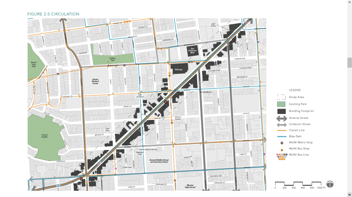
One can see some ambiguities regarding the function of surface streets emerging in the conflict over space. As cars and the need for public transit overwhelm the existing arterial and collector streets the traffic spills into the adjoining neighborhood streets. These streets in turn require all kinds of expensive mitigation and facilitation infrastructure. And as fast as we build it, more cars come…
|
TABLE 2: DESIGN GUIDELINES FOR STREETS
Design of streetscape and pedestrian elements should follow the policies and guidelines for the appropriate street type as described in the Better Streets Plan, as adopted by the Board of Supervisors. The Better Streets Plan is incorporated herein by reference. The street types in the Better Streets Plan are intended to guide the design of streetscape and pedestrian features, and not to replace functional transportation classifications. |
| Major and Secondary Arterials
Where residential uses abut on major and secondary arterials, they should be screened visually and physically wherever possible. A consistent pattern of trees at regular intervals should be used to identify major streets. Medians should be landscaped with attention given not to diminish the safety and sightlines of traffic, especially at intersections. Extensive buffers should be used to separate busy arterials from active pedestrian areas. Sufficient space should be provided in the right-of-way to allow safe bicycle movement on all city streets. The brightness (apparent illumination) of street lighting should be greater than on residential streets. Destination information should be concentrated on major streets with signs used to route traffic on the major streets system. Local Residential Streets Excessive traffic speeds and volumes should be restricted and discouraged by every means possible per Policy 18.4. Where possible, vehicular access directly to and from local streets should be from other than major arterials, e.g., via a secondary arterial or collector street. When alternate access is possible, residences should not access to major arterials. Local streets, other than collectors, should be primarily for access to residences and to serve for emergency vehicles; pedestrian-dominant streets with the maximum feasible amount of street space devoted to environmental amenities desired and needed by the residents. Residential streets should be well-lighted without being excessively bright. Sufficient space should be provided in the right-of-way to allow safe bicycle movement on all city streets. Intersections All intersections should accommodate safe pedestrian crossings. Accommodations may include bulb-outs to shorten the distance that pedestrians must cross; pedestrian refugees in the middle of major arterials such as Market Street, for pedestrians to rest safely if they do not cross within one light cycle; pedestrian signals; pedestrian-priority signal timing; and other pedestrian facilities. Every street intersection should accommodate pedestrian crossings safely; intersections that sacrifice pedestrians crossing opportunities to better accommodate automobile traffic should be re-designed. Street width, traffic controls, destination and route information and illumination should be maximized at the intersection of two major arterials. Two intersecting residential streets should have minimal roadway width, wide sidewalks and no change in illumination from that on the streets themselves. Intersections of residential streets and major arterials that are not transit corridors should be minimized; where they must intersect, cross and left-turn movements should be limited by curb alignments or medians. |
|
TABLE 3: GUIDE TO THE VEHICLE CIRCULATION PLAN
NOTE: This section refers to the Vehicle Circulation Plan map. Except where indicated no increase in the vehicular capacity of any thoroughfare is intended. |
| (Note: a more extensive version of this table is available.) Guerrero Street Although Guerrero, Valencia and South Van Ness serve as major and secondary arterials at the present, the improvement of transit service should be accompanied by steps to reduce through traffic and make these streets more compatible with residential uses. Market Street Market Street should be honored and protected as San Francisco’s visual and functional spine. The City should engage in a comprehensive redesign of Market Street from the Embarcadero to Castro Street. Improvements to Market Street should emphasize its importance for pedestrians, cyclists, and transit. Valencia Street This street should act as a neighborhood collector street as well as a principal bicycle arterial. |
