While 17th Street from Church Street all the way to Castro Street is part of the official city bike plan that was approved by several city agencies it was never installed back in 2011. Nope, they installed the rest of the path all the way to the San Francisco Bay and the part that goes up Twin Peaks following Corbet from Upper 17th. But they just plain skipped that one section. Ya ever wonder why?
Because it is an engineered bike trap and is so obviously dangerous that The City’s own engineers just tossed up their hands and said, “to hell with it.” In the past ten years this unusually tight configuration of parking (and double parking) and streetcar tracks has sent more bicycle riders to the hospital than most folks can imagine. Interestingly enough the Department of Parking and Traffic studied part of this dynamic back in 2004 when they pioneered the use of sharrows. That study yielded the base diagrams and assumptions that I have extrapolated into this 17th Street specific extension of that work.
Remember that this is a two way street so we are simplifying the overall dynamic a bit by limiting our model to one side (North) of the street. That said, let’s see for ourselves what thwarted the bike lane engineers back in 2011 when they were trying to figure out where to paint the lines in the pavement that would guide bikes to the safest part of the street.
Let’s start with the easiest example. A perfect moment on 17th Street with cars parked perfectly and the tracks empty in the center of the traffic lane. Joy be to all. Clear sailing.
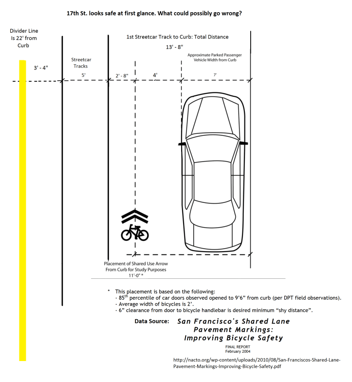
So far so good. Normally the sharrow or lane marking could go in right where it is indicated above and in the next slide. As we will see, even if the driver of the parked car opens his door this has been foreseen and should be okay. SFMTA actually did a study and measured the average bike rider and the average door and car to figure all this out. Let’s see what they found.

So far so good. Nothing to stop an engineer from painting a line so far. But let’s keep looking. Those train tracks on the riders left. Muni uses those tracks for big old President’s Conference Commission streetcars pulling into service straight out of Cameron Beach Yards out by San Jose & Geneva Avenues (City College, Balboa Park area). If the cars are all parked nicely that doesn’t pose a huge problem although moving huge trains are not ideal so close to bikes and passing right by.
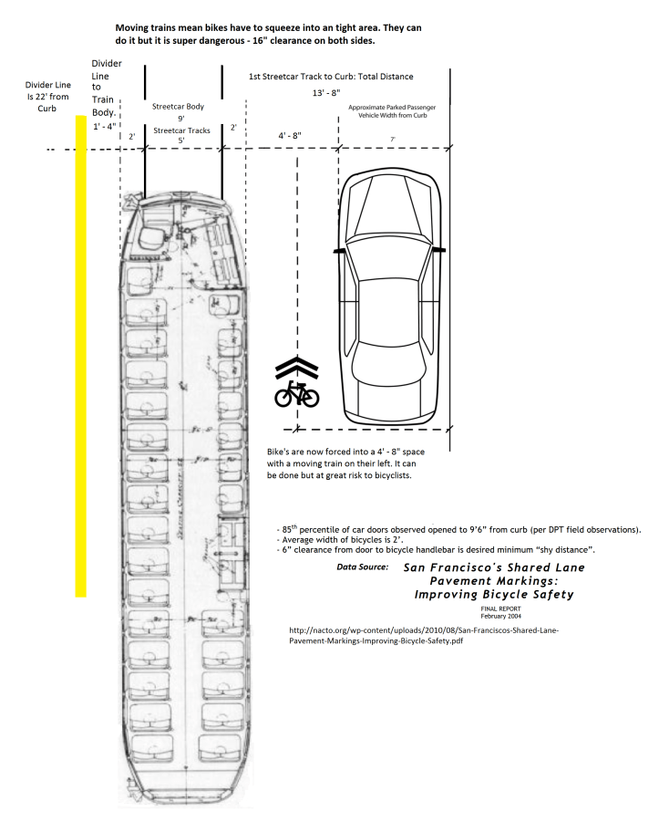
Okay, in all three scenarios above the bike lane could be painted in the normal spot in theory but for the fact that the bike lane should be five feet wide. So we could conceivably step down to sharrows as the illustrations already presume. The problem is that several other things happen on the roadway that need to be diagrammed and considered very carefully before one declares any specific route to be safe for bikes.
What happens if someone is getting out of their car at the same time as a streetcar goes by. If bikes are passing through that configuration it can emerge on them in real time much faster than one might think. Let’s see what happens then.
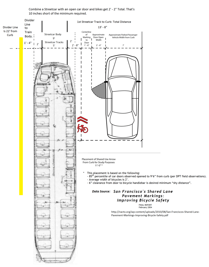
Now where would you put that sharrow? If our bicyclist is to survive the situation above they have to pass through a hole with one inch on each side to spare. If they are one of the bicyclists that are wider than 2′ – 2″ then all bets are off. At this point the 17th Street bike path is impassible.
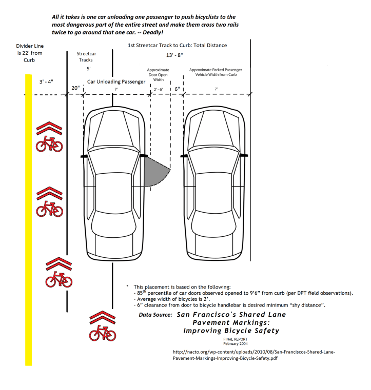
The other way people get maimed on the 17th Street Bike Path is crossing the tracks to go around double parked cars unloading passengers. Now double parking is common in San Francisco. Nothing new there. But when it happens in conjunction with deeply rutted train tracks it poses a special challenge to bicyclists. Going around the car requires crossing dangerous rails four individual times.
As if crossing the rails wasn’t bad enough, it gets worse. The placement of the second rail combines with the placement of the double parked car to push the bike rider all the way to the center of the street, right along the dividing line. Here they are vulnerable from both sides with average traffic flow easily approaching 35 miles per hour and two way streetcar traffic.
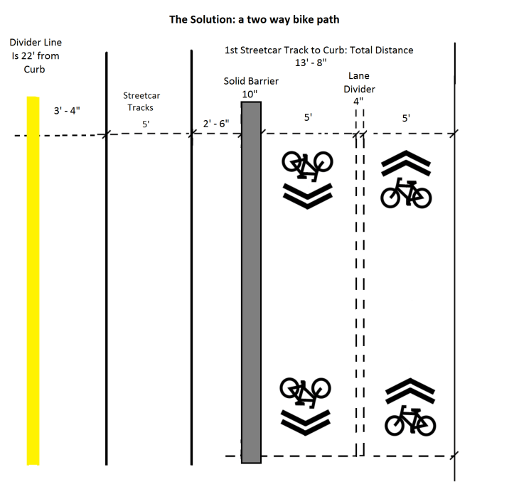
So now we see the problem. The street as currently configured really is an engineered bicycle trap. And the engineers for the City knew this totally five years ago. And had the politicians not interfered with the process back in 2011 we humbly suggest to you that the best solution for the bicycle safety aspect of this problem looks a lot like our final diagram below. Basically the answer is to remove the bikes from the road entirely by moving them to a two way separated bike path.
We pray that The City consider this redesign as a first step toward legalizing 17th Street! Following this initial step we urge more efforts to remove the tracks as they impede disability access and clutter up the crosswalks and intersections. And beyond that we urge curb cuts where needed on 17th Street and a legally sloped ADA access ramp for the F-line streetcar terminal at Castro Street.
‘Nuff Said!
Link to our sister site for overall presentation purposes.
