The story of the 17th Street bike path is much more complex than one would ever figure at first glance. The path currently runs from the waterfront down by Illinois Street and Third Street all the way up 17th Street past the Castro and a good ways up Twin Peaks. It is the route to take from a safety and ease of ride perspective.
The bike path mostly follows 17th Street with one glaring three block hole from Church Street to Castro Street then it goes uphill on 17th Street ’till Corbett Street which is the easiest grade right up to the top of Twin Peaks with sharrows running up Corbett.
Looking at it now one might ask whats so difficult about painting a couple of lines on a side street for a mile or two? You’d never suspect that millions and millions of dollars and years of planning and analysis went into those little lines on the road. Engineers and architects mapped and planned every inch of that path in detail for its entire length and litigants fought in court for five whole years before the first line was painted.
As far as I can tell the idea of the 17th Street Bike Plan was hatched sometime around 2005. Support grew and other bike corridors around the city were also mapped out. The idea was a city wide bike path system.
A group called C.A.R. — Coalition for Adequate Review saw this concept as a threat to automobile drivers and fought the plan in court by demanding all sorts of environmental impact documentation. The City rose to the occasion to defeat that group in court and in 2010 or so the bike lanes started the journey from the drawing board to the pavement.
To tell the rest of the tale I will pull material from several web based resources and link to the original articles for the readers convenience.
We will start with StreetsBLOG SF from February 11, 2011 where writer Aaron Bialick penned: “Eyes on the Street: SFMTA Crews Begin Striping 17th Street Bike Lanes.”
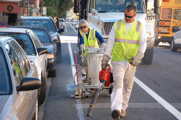
Bicyclists have begun taking advantage of the new bike lanes being installed this week along the western section of the 17th Street corridor, with many riders saying they began feeling a greater sense of safety just as soon as the first stripes were laid down by Wednesday from Valencia to Church Streets.
In interviews with Streetsblog, several people on bikes roundly cheered the improvements, described as simply “fantastic” by one rider. “It’s really nice because we always bike on 17th Street and the [car] traffic is not that high,” said another traveler trying out the new lanes with a partner.
“Improvements on 17th Street will help the fast-growing number of people bicycling between the Castro, Mission and Potrero neighborhoods,” said San Francisco Bicycle Coalition executive director Leah Shahum. “There are so many families with children riding bicycles in these areas already, and this new bike lane will help welcome even more people of all ages onto their bicycles.”
SFMTA counts show a 75 percent increase in bike traffic on 17th Street at Valencia from 2006-2010, according to Shahum. The long-awaited project comes as part of the San Francisco Bike Plan, which is currently being put into action after a four-year bike injunction delay.
While SFMTA crews have begun work along the roughly two-mile stretch from Corbett Avenue to Kansas Street, bike lanes between Church and Sanchez are temporarily on hold as planners try to figure out a solution that addresses safety concerns about the streetcar tracks, according to the SFMTA Sustainable Streets Division’s Mike Sallaberry.
The lanes approved in the Bike Plan would have directed riders through the 17th and Church Street intersection at an angle intended to avoid catching bicycle tires in the streetcar tracks, but the westbound bike lane ends at Church Street in the latest layout presented on the SFMTA’s website [pdf].
If bike lanes were to be striped on that section of 17th Street, they would be placed between the tracks and parked vehicles, squeezing bicyclists into a narrow space. A safer solution would be to replace the curbside parking, but, for now, Sallaberry said the SFMTA is considering installing sharrows in the center of each set of tracks.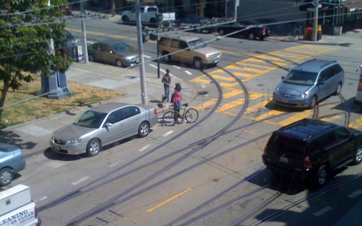
“It is important that the city upgrades 17th Street to be safe and inviting along the entire route,” said Shahum. “We want to be able to welcome anyone from ages eight to eighty onto their bikes on this important east-west route, so it should be a continuous, dedicated bike space.”

Replacing parking with safer curbside bike lanes is already part of the 17th Street project on the eastern section from Valencia to Kansas Streets, where upwards of 200 vehicle spaces will be re-purposed. While parking demand factors could be at play in the differing treatment, the relative impact of replacing the roughly forty spots between Church and Sanchez does seem smaller for a block that likely also holds greater demand for safe cycling travel.
SFMTA crews also striped a new dashed left-turn bike lane on 16th Street this week, making room between existing travel lanes from Sanchez to Market Streets as laid out in the Bike Plan, although the design appears to be a tweak from the original [pdf].

Sharrows can be found on blocks of Hoff and 16th Streets directing riders from the bike routes of 17th and Valencia Streets to the 16th and Mission BART station as part of the project. Photo: Aaron Bialick.

Riders take advantage of the newly separating stripe. I personally prefer the aesthetic of this leftover sharrow marking to the standard bike lane stencil. Photo: Aaron Bialick.
Videos of bike wrecks from 17th Street Tracks
Next we jump ahead a year or two to Friday, November 16,2012 Streetsblog, writer Aaron Bialick continuing the story…”SFMTA Adds Markings to Guide Cyclists Across Tracks at 17th and Church“

The SF Municipal Transportation Agency is testing out new street markings to help cyclists safely negotiate hairy intersections where bike routes and rail tracks meet.
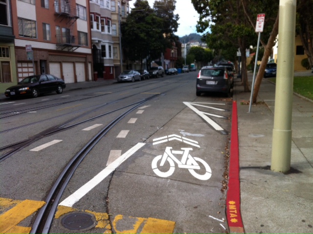
The SFMTA added guidance markings this week to the intersection of 17th and Church Streets, where the 17th Street bike lane meets Muni’s F-Market and J-Church streetcar lines. Car parking spots near the corners were also removed to improve visibility and provide more room for cyclists to maneuver safely.
The dashed lines and sharrows direct cyclists to cross the tracks at nearly a perpendicular angle, which minimizes the risk that bike wheels will get caught in the track crevices — a common bicycling hazard in San Francisco. Similar treatments have been used in Seattle.
“We’ve heard reports of crashes at 17th/Church and are trying this design to determine if it’s effective in improving the angle people take when they ride across the tracks,” said Mike Sallaberry of the SFMTA’s Livable Streets Subdivision. “We’ve taken some observations already and will continue to do that to see if the design could be improved or applied elsewhere.”
Although SFMTA planners have also discussed adding similar markings at the bike and transit junction of Church and Duboce Avenue, Sallaberry didn’t say if those will be implemented.
Similar track-crossing markings were included in the 17th Street Bike Plan project, which originally proposed extending the bike lane west of Church. The plan was revised to cut the bike lane short, to avoid directing bicyclists to ride in the narrow space between parked cars and passing trolley cars. Instead, bicyclists are expected to share the lane with trolleys.
Removing the car parking lanes on that block of 17th, while politically contentious, could provide a much safer space for people cycling on the street, but there are no known plans to do so.
Additional Web Resources
https://www.sfbike.org/news/you-said-sfs-next-bike-projects/
https://www.sfmta.com/sites/default/files/projects/MTABpacketandresolution07_012.pdf
This last bit of research needs it’s own space because it is so vast:
http://sf-planning.org/environmental-impact-reports-negative-declarations
San Francisco Bicycle Plan
Final Environmental Impact Report
http://sfmea.sfplanning.org/2007.0347E_FEIR4b1.pdf — try page 42, cool technical drawings.
